
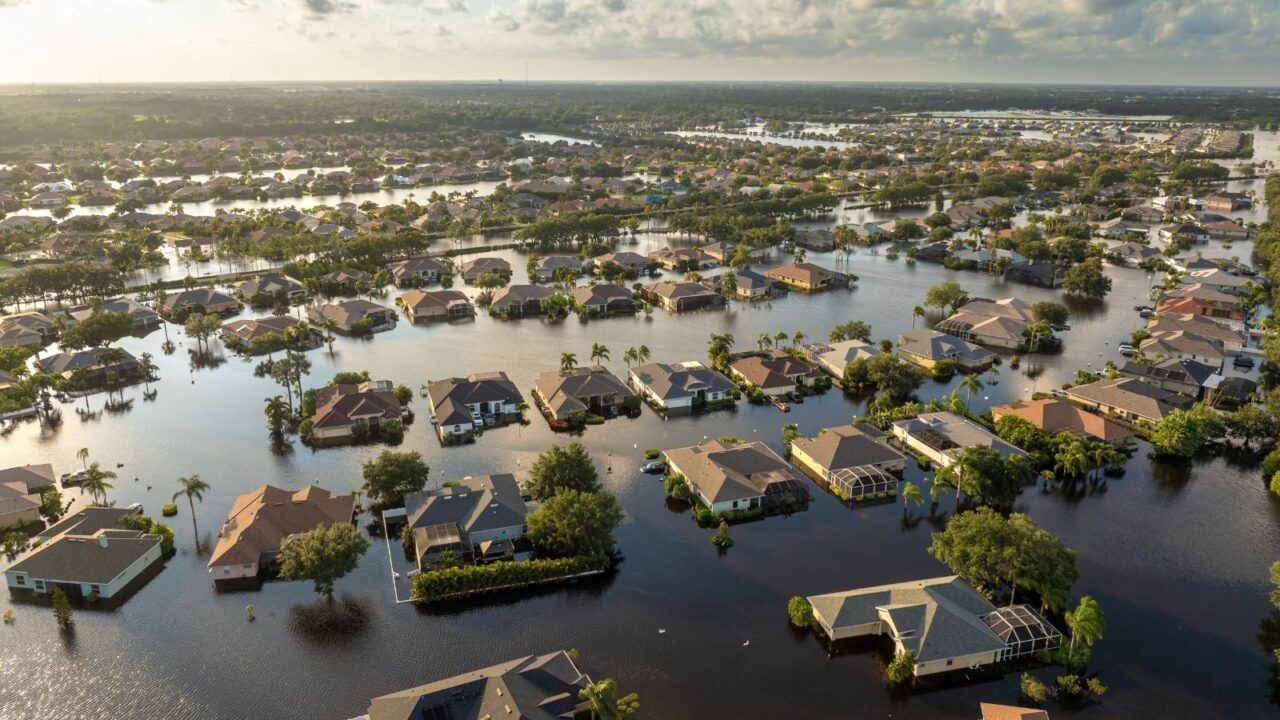
East Coast braces for rare storm surge
A powerful tropical storm is hitting the U.S. East Coast, bringing high winds, heavy rain, and storm surges that could reach 4–5 feet in some areas. Residents along barrier islands and estuaries are already seeing flooding in low-lying neighborhoods, with beach erosion becoming a concern.
This surge is considered among the highest in recent years, putting roads, homes, and coastal infrastructure at risk. Authorities are urging caution and preparing for potential evacuations where water levels rise significantly.

Travel disruptions expected coast to coast
Flights along the East Coast are facing hundreds of delays and cancellations due to strong winds and rainfall, especially from New Jersey to Massachusetts. Major highways may close, and fallen trees could block local roads.
Rail and bus services are also affected, leaving travelers with fewer options. Experts recommend checking travel updates frequently and allowing extra time if you must be on the move.

Heavy rainfall and flooding threats
Some coastal areas in the Carolinas have already received 10–11 inches of rain, saturating the ground and increasing flood risk. Light rain and drizzle will continue through Tuesday in other regions.
Flooding is compounded by multiple high tides over the next couple of days. Saltwater intrusion could damage vehicles and property, especially near estuaries and coastal communities.

Strong winds bring damage risk
Gusts over 55 mph have been reported in parts of New Jersey and Long Island, causing power outages and minor property damage. Trees and weak structures are particularly vulnerable to the sustained winds.
Residents are advised to secure outdoor items and avoid travel in areas with downed power lines. Wind combined with water can make certain zones especially hazardous.
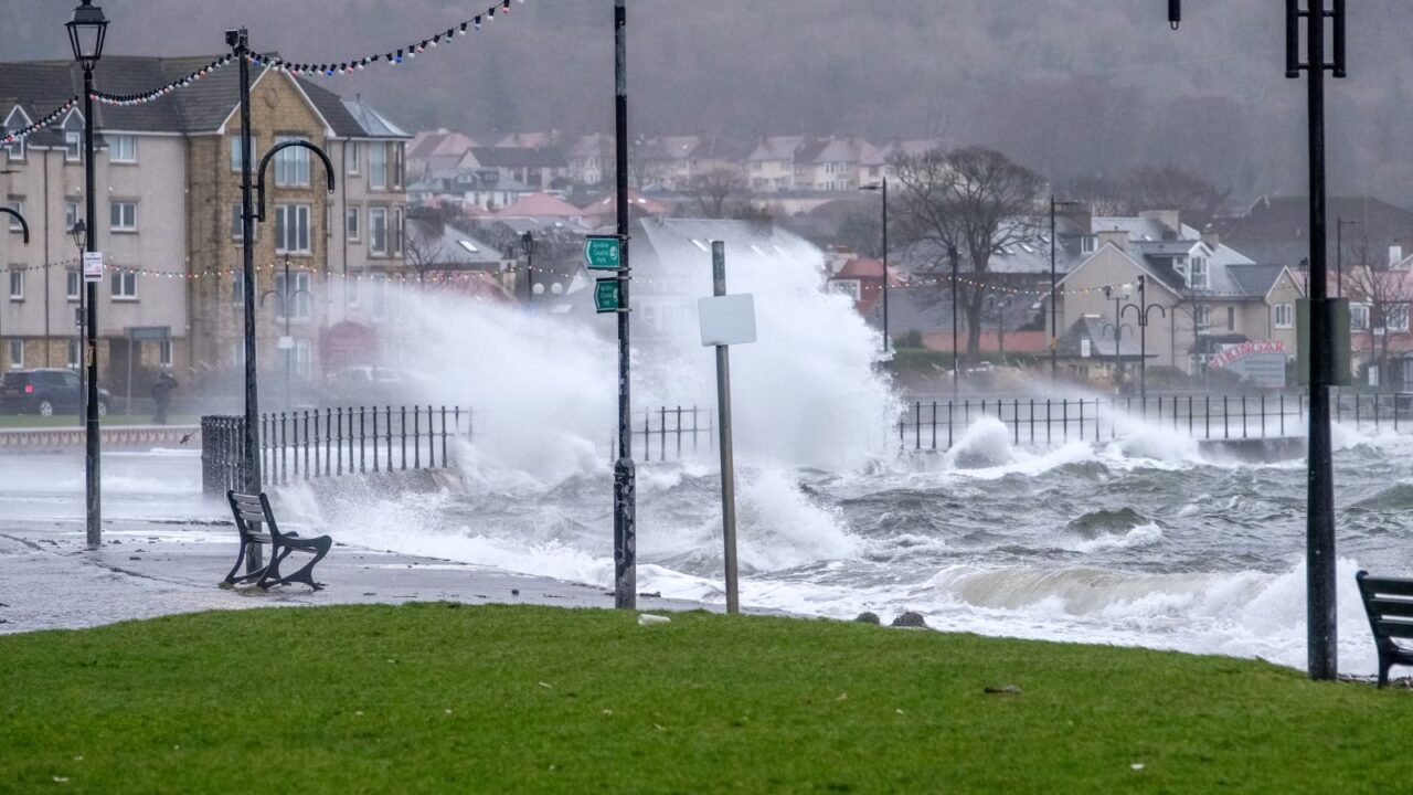
Storm surge timing is critical
The worst flooding is expected during high tide cycles over the next two days. Coastal streets and beachfront properties may experience persistent inundation, and local authorities are already deploying sandbags and barriers to help protect homes.
Even areas a mile inland could see temporary flooding if the surge coincides with peak tides. Preparation now is key to minimizing damage, and residents are being urged to stay alert to changing water levels and follow safety advisories.

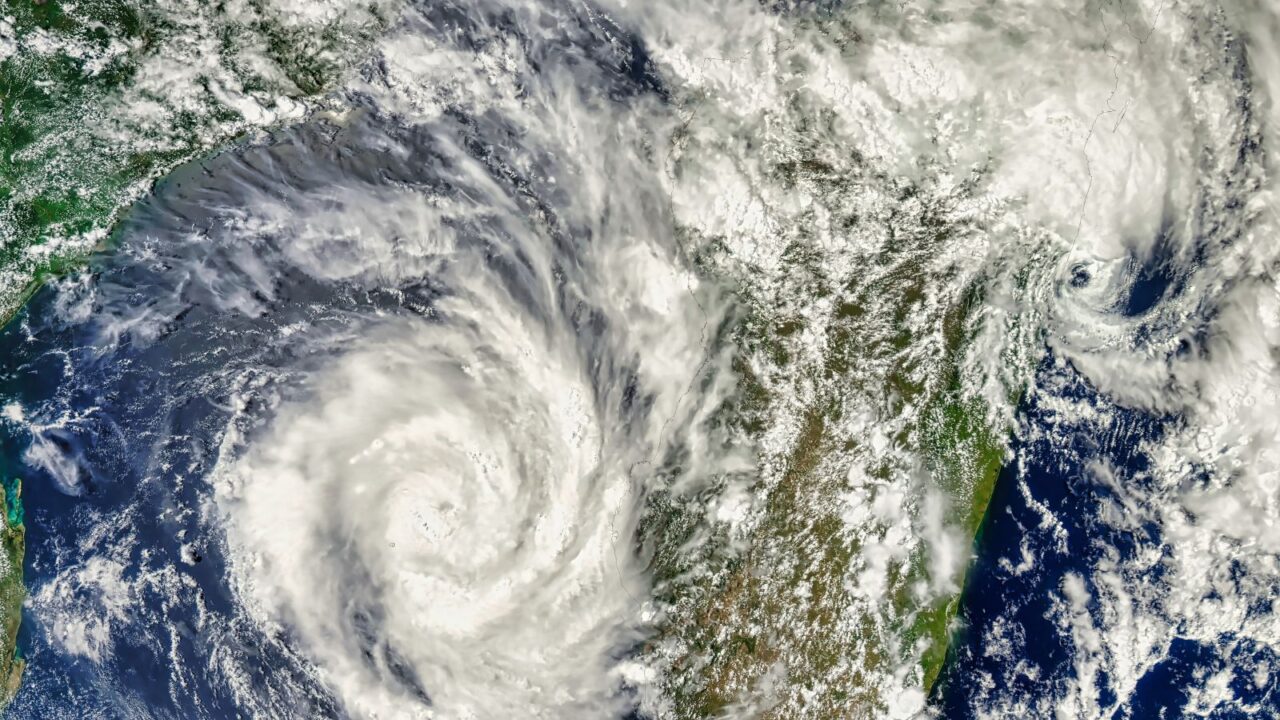
Tropical Storm Erin forming in Atlantic
Erin is forecast to become a hurricane later this week, adding to an already active 2025 season. Meteorologists expect it to strengthen rapidly into a major hurricane later this week.
Erin’s track could affect the U.S. East Coast next week, though exact landfall locations remain uncertain. Forecasters are closely monitoring its path to give timely warnings.
Erin’s early impacts abroad
Erin caused flash flooding in São Vicente, Cape Verde, with several casualties reported. Rainfall of 7–8 inches in a few hours led to dangerous conditions across the islands, forcing some residents to evacuate low-lying neighborhoods.
This early activity highlights how quickly the storm has strengthened over warm Atlantic waters. Officials worldwide are watching for further intensification, preparing resources in case the storm escalates further.

Factors fueling rapid strengthening
Low wind shear, warm water, and dry air-free zones allow Erin to organize quickly. Forecasters note that these conditions could support major hurricane development soon, making early tracking essential for coastal safety.
The Bermuda High and jet stream patterns will influence the storm’s future path. Any shift could bring stronger winds or higher surges to coastal areas, affecting both residents and marine traffic.
U.S. East Coast impact zones
Potentially affected areas include the Carolinas, Long Island, New York, Cape Cod, and New England. Coastal flooding, rough surf, and gusty winds could disrupt beach towns, local businesses, and commuter travel.
Residents should stay alert to local advisories and evacuations. Even a hurricane passing offshore can create dangerous storm conditions along the coastline, emphasizing the need for preparedness.

Warnings for Bermuda and Bahamas
Bermuda and the Bahamas may face high winds, rough surf, and hazardous conditions over the next several days. Authorities recommend monitoring the storm closely and taking precautions to protect property and lives.
Travelers and residents should stay near safe shelters and avoid venturing into exposed coastal zones. Lifeguards and emergency services are preparing for potential rescues and emergency operations.

Canada could feel effects too
Nova Scotia and Newfoundland may experience significant winds, rain, and coastal surges from Erin late next week. Canadian authorities are issuing early alerts for impacted areas, urging residents to take storm preparations seriously.
The storm’s reach may extend far north, causing high seas and localized flooding. Residents should plan for possible disruptions to travel and outdoor activities, and secure vulnerable property.

Gulf of Mexico monitoring
Thunderstorm activity in the northeast Gulf is being watched for possible tropical development. Heavy rains could bring localized flooding to Florida, Alabama, Mississippi, and southeastern Louisiana, especially in low-lying communities.
Small craft and beachgoers should exercise caution. Even minor depressions can cause dangerous squalls and flash floods in low-lying regions, making boating or beach plans risky.

Atlantic-wide storm watch
Several other Atlantic areas are being monitored for tropical activity this week, including clusters off Africa and the Carolina coast. Forecasters warn these could affect the Caribbean or U.S. later, so early observation is critical.
Tracking these systems helps give early warnings for shipping, travel, and coastal communities. Preparation now can reduce future risk, keeping lives and property safer during storm season.
In other news, check out what Hurricane Melissa means for Jamaica’s travel season.
Preparing for storms and surges
Residents should secure outdoor items, maintain emergency kits, and stay updated on official advisories. Coastal evacuation plans may be needed for some communities, depending on the storm’s intensity.
Monitoring apps, news outlets, and local authorities will provide real-time updates. Staying proactive is the best way to minimize storm-related damage and reduce panic during severe weather events. Next, check out how the Caribbean is rebuilding and welcoming visitors again after the storm season
How are you preparing for Erin’s impact? Share your tips and experiences.
Read more from This Brand:
- Air Canada announces return to key U.S. airports
- Las Vegas locals get big discounts as tourism declines
- Australia stays strong as a bright spot in U.S. tourism
Don’t forget to follow us for more exclusive content right here on MSN.
This slideshow was made with AI assistance and human editing.