
Coastal cities update guides
U.S. coastal cities are starting to include tidal flooding alerts in their visitor guides. Places like Charleston, Norfolk, and Miami are leading the way. These updates help travelers plan around high tides and sudden water surges.
Alerts appear in brochures, websites, and mobile apps. They explain which streets, boardwalks, and low-lying areas are most affected. That kind of transparency improves both safety and enjoyment.

Charleston takes proactive steps
Charleston’s historic downtown sees occasional tidal flooding during spring and summer. The city now flags streets and landmarks at risk in visitor guides. Tourists can check tides before walking through waterfront areas.
Local maps highlight affected zones during king tides. Hotels and tour operators reference alerts for planning. Travelers can explore with awareness and peace of mind.
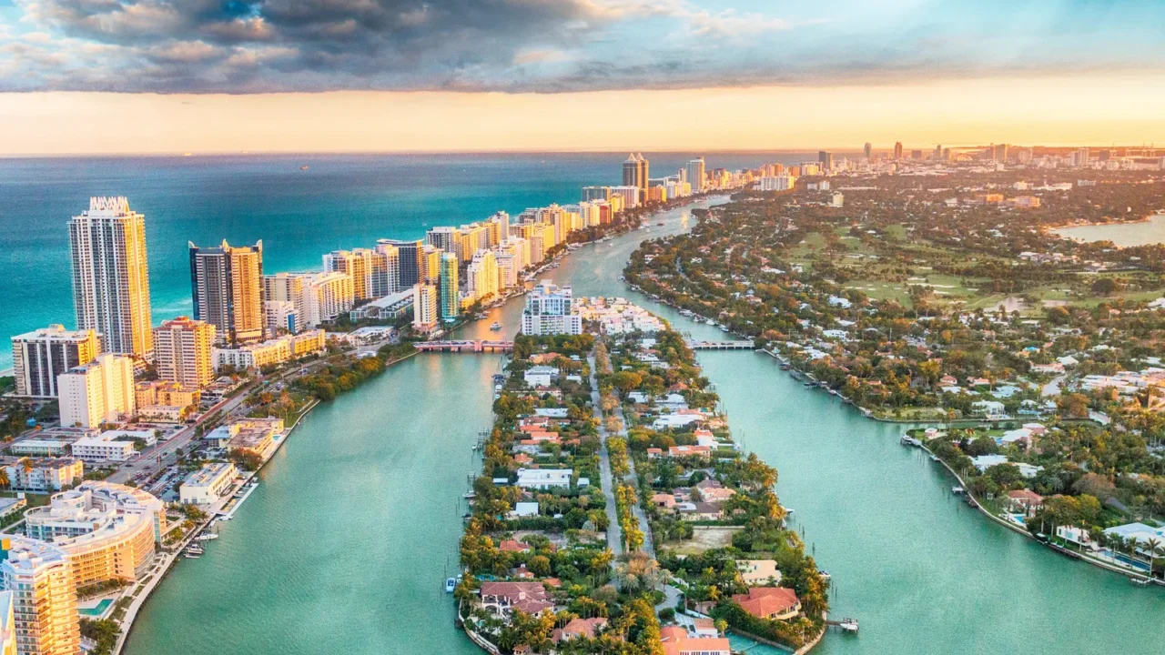
Miami integrates alerts
Miami Beach adds tidal warnings to digital visitor resources. Rising tides affect Collins Avenue and beachfront promenades. Alerts guide visitors on safer routes around low-lying areas.
Public signage supplements online notices for immediate awareness. Walking tours and bike paths are included in updates. That approach keeps activities accessible while avoiding hazards.

Norfolk emphasizes planning
Norfolk includes tidal forecasts in visitor planning materials. Waterfront parks and piers are highlighted for potential flooding. Travelers receive real-time updates to avoid disruptions.
Tour operators adjust boat tours based on tides. Restaurants along the Elizabeth River include tips for arriving safely. Awareness becomes a part of the overall travel experience.

Boston joins the trend
Boston updates its Freedom Trail and waterfront guides with flooding information. High tides affect areas like Long Wharf and the Seaport District. Guides advise timing visits to avoid submerged sidewalks.
Public apps sync with NOAA data for accuracy. Hotels and ferries pass along alerts to guests. That system balances historic exploration with safety considerations.

New York City adapts guides
NYC now flags low-lying neighborhoods like Lower Manhattan and the Battery for tidal flooding. Waterfront attractions include advisory notices in visitor materials. Travelers can check tide tables before visiting piers and promenades.
The city combines digital alerts with on-site signage. Ferry schedules and boardwalk tours adapt when flooding risk rises. That coordination helps maintain normal activity with safety in mind.

San Francisco includes projections
San Francisco warns visitors about high tides along the Embarcadero and Marina District. Guides indicate areas prone to seasonal flooding or storm surges. Visitors can plan walking tours without unexpected interruptions.
Local apps integrate tides with weather predictions. Hotels suggest alternative routes during peak events. That foresight keeps experiences smooth and enjoyable.
New Orleans updates materials
New Orleans adds tidal alerts for the French Quarter and riverfront parks. Seasonal high tides impact streets near the Mississippi River. Visitor guides now show which areas may be temporarily submerged.
Tour operators highlight safe walking and biking paths. Restaurants and cultural venues advise guests when areas flood. The city aims for safety without restricting access to attractions.

Annapolis flags waterfront areas
Annapolis includes tidal warnings in brochures and online guides. The historic downtown and Navy Yard are highlighted. Visitors see when piers and marinas may be inaccessible.
Walking tours of colonial streets adjust schedules accordingly. Boat rentals receive real-time updates on water levels. That way, sightseeing remains safe and uninterrupted.

Key West incorporates alerts
Key West flags low-lying streets and coastal paths in visitor guides. Rising tides affect Duval Street and nearby beachfronts. Travelers can shift schedules to avoid submerged sidewalks.
Local apps track tides hourly during king tide events. Hotels and shops post visible warnings for awareness. That proactive approach supports both enjoyment and safety.

Portland, Maine joins in
Portland integrates tidal alerts for Old Port and Eastern Promenade. Waterfront restaurants and piers are prone to temporary flooding. Guides help visitors plan walking tours around high tides.
Marinas and ferry operators also share updates. Travelers experience waterfront attractions safely without surprises. Awareness becomes part of the city’s charm.
Mobile, Alabama implements guides
Mobile adds tidal alerts for downtown streets and riverfront parks. Seasonal high tides can affect historic districts and walking routes, and coastal hotels are redesigning rooms specifically for storm watching as part of adapting to changing conditions. Visitor guides clearly indicate flood-prone zones to help travelers plan.
Boat tours and water activities reference alerts for scheduling. Restaurants and shops update staff to inform tourists. Travelers appreciate guidance that balances fun and caution.
Travel safety meets planning
U.S. coastal cities are using tidal alerts to help travelers plan smarter trips. Charleston, Miami, Norfolk, and beyond provide tools to avoid disruptions. Safety and enjoyment go hand in hand.
These alerts give visitors confidence when exploring waterfronts. Trips stay memorable without unexpected setbacks. Coastal travel adapts naturally to climate realities while keeping the experience vibrant.
If you found this interesting, give us a like and share your thoughts in the comments.
This slideshow was made with AI assistance and human editing.
Don’t forget to follow us for more exclusive content right here on MSN.
Read More From This Brand: